IN OUR THIRD CENTURY, MEMPHIS WILL BUILD UP, NOT OUT. Memphis will be a city that anchors growth on strengths of the core and neighborhoods; a city of greater connectivity and access; a city of opportunity for all. — Memphis 3.0
After two years, nearly 200 public meetings and events, and engagement of over 15,000 residents, the City of Memphis has released a public draft of the Memphis 3.0 comprehensive plan.
The public draft is the first look at the city’s first comprehensive plan for land use and growth since 1981. The vision articulated in the Memphis 3.0 comprehensive plan is a clear departure from the growth policy of old that resulted in suburban sprawl and urban disinvestment.
The vision of the Memphis 3.0 comprehensive plan calls for the city to “Build Up, Not Out” by focusing resources, investment and policy in growth of the core city and neighborhood centers to create more dense, mixed-use, mixed-income, walkable, transit-served communities.
The city worked with community organizations, artists, and church and school groups, among others, to generate interest and input in the plan. As a result, Memphians came out in historically high numbers to participate in the Memphis 3.0 comprehensive planning process. In all, over 15,000 residents participated in the planning process and thousands more were touched by plan outreach materials.
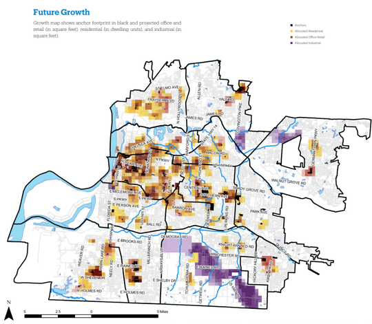
The community was clear in their support of a new plan for growth, one that focused more attention inside the city and within neighborhoods. The plan seeks to address questions of where and how to focus new growth and density, weighing a strategic approach that balances market potential and community priority.
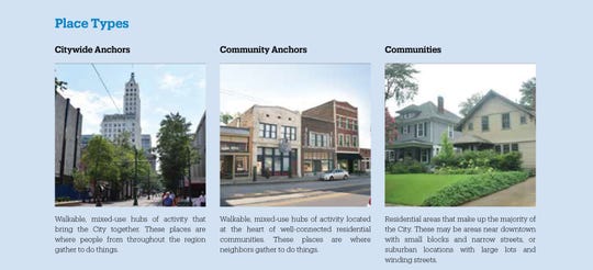
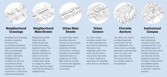
The strategy articulated in the Memphis 3.0 comprehensive plan focuses on places identified as “anchors,” or centers of activity on a citywide scale, such as Downtown, or a community scale, such as a key neighborhood intersection. The idea of focusing on anchors is that the health of a community’s center and surroundings can impact the neighborhood as a whole.
Anchors form the basis of how the comprehensive plan recommends targeting new growth, investment, transportation connections and redevelopment policy. Anchors are defined by their respective degree of change over time:
- Nurture, characterized by areas of low market potential requiring incremental improvements;
- Accelerate, places of moderate to high market activity and high potential for new density and growth;
- Sustain, areas where the city can rely on the market to maintain current density while making necessary improvements.
Guiding our land use
The Framework for Growth chapter of the comprehensive plan outlines this focus on anchors and its relationship to other major elements of the plan, including the land use plan and the transit vision.
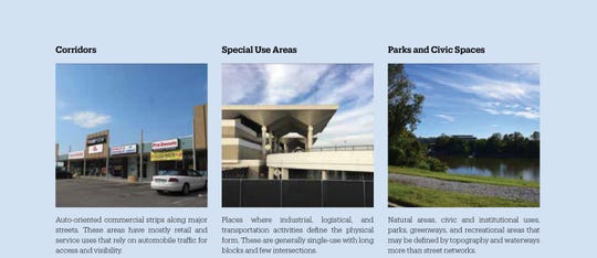
The first of its kind for Memphis, the land use plan in Memphis 3.0 lays out recommended future land use for the entire city. Given finite resources, the purpose of anchors provides strategic priorities for where and how to invest city resources while providing a clear vision on where growth and investment is encouraged throughout Memphis.
Essential to reading the land use map is an understanding of what it is and what it is not. As the plan states, all anchors are walkable, mixed-use places, but that doesn’t mean that they’re all the same. And change in anchors is context-sensitive, not all or nothing.
The focus on anchors aims to illustrate a focus on key areas of the city where growth, development, and change occur and surrounding it where greater density can be built to support anchors through a mix of housing types. In that way, the future land use map provides a guide for where and how change can and should occur.
It does not replace zoning or the zoning map in the Unified Development Code (UDC). As projects are submitted for planned developments, variances or other zoning entitlements, the plan gives the Office of Planning and Development (OPD) a much-needed tool to elevate community priorities and design citywide.
Along with guiding future land use, the comprehensive plan also includes guidance for other city systems, beginning with the city’s streets. As a companion to the land use plan, the Memphis 3.0 comprehensive plan includes new recommendations for street design to align with surrounding land use to create more walkable, transit-served neighborhoods.
Vision for transit
The plan also includes the Memphis 3.0 Transit Vision, an effort recommending both short- and long-term maps that focus resources on greater frequency in the transit system to maximize ridership and improvement in commute times – more buses more often.
Public transit was a frequent priority articulated by residents in the planning process. The recommended transit network design achieves directness through its linking of recommended plan anchors, primarily along key corridors. The goal of frequency is achieved through improving service levels along key routes, primarily those that connect to and among the core of the network, but greater density is essential to sustaining a high frequency network. If implemented today, the recommended short-term network brings an additional 79,000 people and 103,000 jobs within one-half mile of frequent transit (service every 15 minutes).
Many of the plan’s recommendations come in the form of policies and potential investments, organized in the plan elements of Land, Connectivity and Opportunity. Within the plan elements are eight goals addressing communities and development, civic spaces, sustainability, infrastructure, transportation, economic development, housing and community engagement. Not all recommendations will be implemented immediately, but vary among short-term, medium-term and long-term in nature.
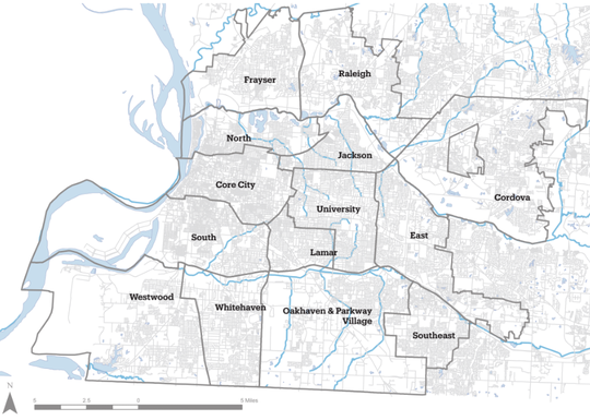
Finally, the comprehensive plan contains district character plans for each planning district area of the city. Within these, residents can find recommendations on anchors, land use, transportation and key actions for each district. Many of the plan’s policy and investment recommendations are citywide in scale, but some actions were priorities specific to each district or even by anchor area.
John Zeanah is director at Memphis and Shelby County Division of Planning and Development.
Key dates
Jan. 31: The Office of Comprehensive Planning will host a final presentations on the Memphis 3.0 plan from 5:30-7:30 p.m. at the Memphis Bioworks Foundation, 20 Dudley Street, Suite 900.
The presentation will review the growth and development strategy that the plan supports, along with implementation priorities. A brief question-and-answer period will follow. Please share with others and we hope to see you there!
Feb. 8: The comment period for the Memphis 3.0 public draft ends. Residents are asked to review the plan and provide comment by visiting memphis3point0.com. Comments will be reviewed and incorporated into the final draft as appropriate.
Feb. 14: The Memphis and Shelby County Land Use Control Board will consider adoption of the plan during its regular meeting. If approved, plan adoption will advance to City Council for adoption by ordinance.


